
As coastal property crumbles into encroaching seas, villagers receive plots with fish ponds on a free lease to help them stay afloat
By Rafiqul Islam
HATIYA, Bangladesh, Jan 14 (Thomson Reuters Foundation) - Ferdousi Akter's family struggled to survive after a crumbling riverbank forced them to abandon their home and move to a new part of the island where they live, off the Bangladesh coast.
Her husband worked as a day labourer on fishing boats but earned too little to cover their expenses.
Just over a year ago, however, the five-member Akter family was one of 45 households offered land on Hatiya Island under a decade-long free lease by the Bangladesh Forest Department.
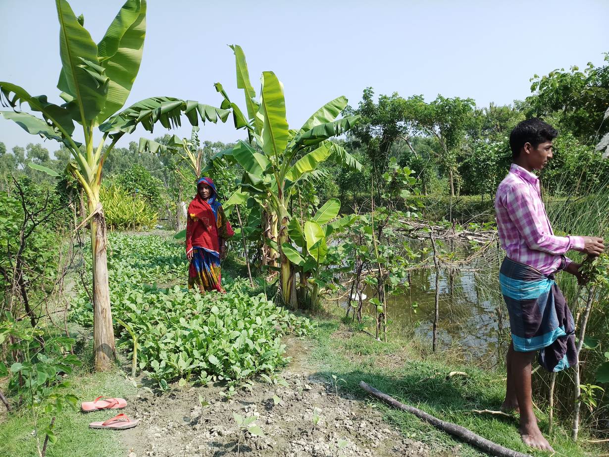
"I got a pond and a piece of land for 10 years," said Akter. "Now I am farming fish in the pond and cultivating vegetables on my land - and getting benefits."
She has already sold fish for 10,000 taka ($120), and hopes to increase her earnings to 100,000 taka in the next few months.
Riverbank erosion made worse by heavy monsoon rains upstream had displaced the family repeatedly from their home on Hatiya, a 371-sq km (143-sq mile) island located in an estuary where the Meghna River flows into the northern Bay of Bengal.
A few years ago, the Akters moved to a coastal embankment in another part of the island, where they built a makeshift house.
As more Bangladeshi families are uprooted by climate change pressures, including rising seas and coastal erosion, the Forest Department is distributing fallow land formed from river silt.
Poor, landless people can use the plots without paying rent for 10 years, although they cannot live on the land, as much of it is outside protective embankments.
The land scheme, launched two years ago by the Bangladesh government and the United Nations Development Programme (UNDP), covers Hatiya and some islands in Bhola district.
So far, 9 hectares (22 acres) of fallow land in Hatiya sub-district have been divided up between 45 families who have each received a plot with a pond to farm fish. Fruit and timber tree saplings have also been handed out to plant on the land.
The families have been trained to rear ducks and grow vegetables, so that they can earn more money.
PROTECTING LAND
Demand to participate in the programme is rising by the day, said UNDP community development officer Mizanur Rahman Bhuiyan.
Forest officials said a new effort is underway to distribute another 20 hectares with ponds to 100 families in Hatiya, which has a population of about 500,000 – and the scheme may be expanded further.
"There are huge fallow lands (belonging to) the Forest Department in the islands," said divisional forest officer Islam Towhidul.
Such land is at risk of being appropriated for financial gain by powerful people like politicians and landlords, he said. Leasing the land to vulnerable families can protect it from encroachment, while tackling poverty, he added.
The Forest Department expects the 10-year leases to be extended, he noted.
When the Hatiya homestead and farmland of Mosharraf Hossaion, in his 60s, went under water in 2001 due to erosion by the Meghna River, his life turned into a nightmare.
"Once I had a happy family at Vendar village ... but riverbank erosion snatched away our home and all our belongings," he explained.
Leaving everything behind, Mosharraf's family moved to Aladia village in the same sub-district where they built a house on an embankment right by the sea.
Two other villages were also flooded, uprooting more than 1,000 people, said Mosharraf. They are now at the mercy of extreme events like tidal surges and cyclones each year as they live so close to the sea, he added.
Nizam Majhi said his family's lives had become miserable after they lost not only their home and possessions to sea flooding but also their family ties, leaving them facing an uncertain future.
SEAS CREEP HIGHER
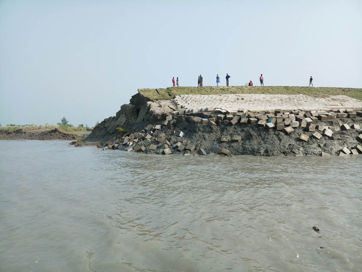
Internal displacement is now common on Hatiya as a large part of the island is being devoured by riverbank erosion accelerated by sea level rise.
The phenomenon is particularly fierce during the monsoon rains when large volumes of water flow downstream.
According to officials at the Bangladesh Water Development Board, several hundred acres of arable land, as well as many houses, markets, mosques, schools, roads, cyclone shelters and 14 km of embankments on Hatiya Island have been gobbled up by seawater in the last two years.
Erosion continues, putting many more islanders at risk of being uprooted.
Villager Majhi said that after losing homes and agricultural land, about 100 families are now living in centres intended as cyclone shelters.
In its 2016 annual report, development group BRAC warned that about 27 million Bangladeshis were predicted to be at risk of sea level rise by 2050, with two-thirds of the country less than 5 metres above sea level.
A 2018 study by the International Food Policy Research Institute and Ohio State University estimated that saltier soils caused by rising seas would push nearly 140,000 coastal residents to move within their districts due to falling income from crops, while about 60,000 would migrate to other districts.
Government data shows sea level rise of about 5.7 mm per year at Char Changa station in Hatiya, and 3.4 mm per year at Hiron Point in the Sundarbans.
Coastal communities are aware of the threat from climate change, as its impacts hit them on an annual basis.
Dewan Hossain, a fisherman in Hatiya, said seawater used to close in on the island's embankment ahead of cyclones, but these days it reaches the embankment every day, flooding many houses on the seaward side, even during a normal tide.
"Seawater was far away from our island in the past, but now I feel the sea is coming nearer to us," said Abdul Khaleque, 45, a resident of Manpura Island in Bhola. One-third of the island has been swamped by the ocean in the past 20-25 years, he added.
Now the sea creeps in as far as the middle of the island through its canal system, affecting a vast area.
"Salinity intrusion is damaging our croplands, putting our lives and livelihoods in trouble," Khaleque said.
($1 = 83.3400 taka)
(Reporting by Rafiqul Islam; editing by Megan Rowling. Please credit the Thomson Reuters Foundation, the charitable arm of Thomson Reuters, that covers humanitarian news, climate change, women's and LGBT+ rights, human trafficking and property rights. Visit http://news.trust.org/climate)
Our Standards: The Thomson Reuters Trust Principles.
